
Siltstone
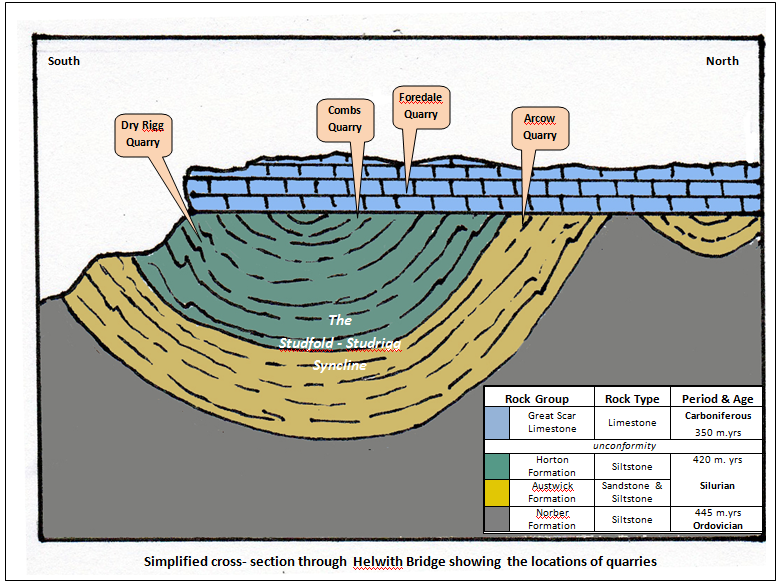
The earliest quarries in the Helwith Bridge area worked rocks of Silurian age (445-420 million years ago) which form part of the 'basement rock' of the Yorkshire Dales. These rocks are divided into a number of 'formations' based on their nature and the quarries are all located in the two thickest: the Austwick Formation and the Horton Formation (see Figure 1 below).
Both formations consist of many beds of siltstone, which is a sedimentary rock in which the size of the grains are between 0.0039 - 0.063 mm in diameter (i.e. between clay and sand). The rock is dark grey in colour and was originally soft sediment that settled from turbidity currents on the floor of a deep sea. On burial the sediment was compacted, driving out most of the water before the grains became cemented by mineral salts that came from the remaining fluids. When the rocks became buried in the roots of a mountain range 400 million years ago, they were heated to 200 - 300°C. This caused some minerals to re-crystallise and the rock to be further hardened. The pressures caused these new minerals to grow in a new direction, which now allows the rock to be split into thin slabs at an angle to (i.e across) the original bedding planes.
The strong nature of the rock and the fact that it could be readily split resulted in it being worked by the earliest quarries for 'flagstones'* and 'slate'*. Later the rock was recognised as forming, when crushed, a very strong, hard wearing and skid resistant road stone and the extracted rock is now used almost exclusively for this purpose. The trade describe this rock as 'gritstone'*, probably because of its tough, hard wearing character.
The once horizontal layers of rock now slope at steep angles because, when compressed within the mountain range, they were deformed into a series of folds. The quarries are all located in various parts of the Studrigg-Studfold Syncline, a downward facing fold which runs NW - SE from Cummackdale, beneath Moughton Moor, to reappear and continue across Ribblesdale (see Figure 2 below).
Limestone
Lying in horizontal layers above the basement rocks are limestones of the Carboniferous age (350 - 335 million years) known as the Great Scar Limestone Group (see Figures 1 & 2 above). Limestone has been (and still is) used for road stone, building and iron smelting. However, in this area it was mainly used to produce agricultural lime.
The sharp horizontal junction between the limestone and the siltstones is an 'unconformity'. It represents a 70 million year gap in the geological record. During this period, the mountain range that once lay across the region was being eroded.
Further reading
The pdf attachment below provides a brief (one page A4) 'Geological History of the area around Helwith Bridge' written by William Fraser.
Footnotes
* These terms were (and still are) used by the quarrying trade, although they are not strictly accurate in geological terms.
Acknowledgments
This article was produced by Mark R. Harvey, but it is derived from - and for the most part, directly quotes / reproduces - material that was kindly supplied by William Fraser. The attached notes were written and illustrated by William Fraser and are used here with prior permission.