Location 'types' with associated definitions
This page provides a definition for each of the 'Location Types' associated with the SCRCA Project. The 'Location Type' classifies each SCRCA site and structure based on its original purpose / function.
Note: If you have JavaScript installed and enabled on your device, clicking / tapping on a term will hide /display the definitions.
'Access Shafts' were originally built to speed-up the construction of long tunnels by allowing multiple tunnelling faces to be worked at the same time. Many have subsequently been converted to air shafts / ventilation shafts, although some were capped at the end of the construction process.
View example locations
A site containing surface and /or sub-surface archaeology associated with the construction of the Settle-Carlisle Railway between 1869 and 1876.
View example locations
A bridge constructed to carry roads, driveways, farm access tracks, footpaths, small streams, etc. over the railway tracks. Also known as an 'over bridge'. Includes overline aqueducts, excludes tunnels.
View example locations
A bridge constructed remote from the main railway alignment that has (or had) a direct association with the railway and a railway-assigned bridge number.
View example locations
A railway tunnel is a long artificial passageway constructed below the ground or through an obstacle such as a hill or large building to create a route for a railway line.
For the purposes of the SCRCA Project, the 'Bridge (Tunnel)' is the hidden structure that lies between a pair of Tunnel Mouths. This distinction has been made because tunnel interiors are not normally visible from outside the railway perimeter, or even from within a moving passenger train (due to the lack of lighting, the speed of the train and the limited angle of view from side windows). 'Tunnels' cannot therefore be 'visited', 'assessed' or photographed by SCRCA Project volunteers. Also, in terms of the management of the Conservation Area, the structural form and physical appearance of 'tunnel' interiors is irrelevant. Finally, listing the component structures separately allows them to be geo-located with a reasonable degree of accuracy. The latter is especially important for the longer tunnels. For example, the Tunnel Mouths for Rise Hill Tunnel are almost two-thirds of a mile apart (1,213 yards / 1,109 metres), while those for Blea Moor Tunnel are more than one and a half miles apart (2,629 yards / 2,404 metres).
For more information about tunnels, please refer to the related article "What are railway tunnels and why are they necessary?".
View example locations
A bridge constructed to allow rivers, streams, roads, driveways, farm access tracks, footpaths, etc. to pass under the railway tracks. Also known as an 'under bridge'. (Excludes viaducts and culverts.)
View example locations
A viaduct is simply a particularly long version of a Bridge (Underline) - i.e. a bridge under (beneath) the railway tracks. Railway viaducts carry (or were originally built to carry) a railway line across a valley or other stretch of ground that is lower than the level of the railway. Embankments (long, thin ridges of made-up ground) can also be used for this purpose, but viaducts can be more stable than high embankments and they occupy a smaller area. Furthermore, the space beneath viaduct spans can be used for other purposes, even if it's just for grazing or access.
For the purposes of the SCRCA Project, any bridge under the railway that has more than three distinct and immediately adjacent spans is classified as a viaduct. However, two 3-arch underline bridges (Sheriff Brow Viaduct / Bridge SAC/27 and Little Viaduct / Bridge SAC/28) have also been classified as viaducts because the word 'viaduct' appears in their commonly used names.
View example locations
A cattle dock is a type of loading platform or loading dock (a.k.a. dock) that was specifically designed to facilitate the loading and unloading of livestock such as cattle, sheep, goats, pigs and geese. The platforms of cattle docks were usually higher than the platforms used by passengers. This allowed livestock to easily and safely walk between the dock platform and adjacent livestock wagons via level or gently-sloping temporary ramps. Cattle docks usually included two or more fenced enclosures (livestock pens) to keep individual wagon-loads of animals together and to stop the animals escaping.
View example locations
Permenantly installed cranes or hoists were provided in most goods yards and goods sheds to facilitate the loading / unloading of heavy and bulky freight.
Unfortunately, none of these structures have survived in-situ within the SCRCA. However, the locations of at least some of the exterior cranes have been identified from the 1911-12 land plans and these have been added to the SCRCA Project database. The records do not appear below as we currently have no photographs featuring any of these structures. However, the skeleton location records can be reviewed via the Gazetteer by selecting 'Crane' in the 'Location Type' filter.
View example locations
Culverts are another form of Bridge (Underline). They allow streams and other small watercourses to pass beneath (under) the railway tracks.
For the purposes of the SCRCA Project, structures have been classified as 'culverts' if that is how they are marked on the 1911 landplan. However, the criteria used by the engineers / draughtsmen when deciding whether to apply the term culvert rather than bridge is not apparent. A quick review of the default images will show that the choice seems to have had little, if anything, to do with the structure's size, design or construction materials. Most culverts include an engineered 'floor' of some kind to direct and speed-up water flow and to eliminate the risk of undercutting. (The latter can be a problem when bridge spans are supported on piers that have been set into or close to the bed of the watercourse.)
View example locations
A "Dock" as marked on the 1911 landplan. Docks in this context are raised platforms that facilitate the loading / unloading and transhipment of general freight.
View example locations
Engine sheds are buildings (or groups of buildings) constructed specifically to facilitate the preparation (start of day), disposal (end of day), light maintenance and short-term storage of railway locomotives. They would usually have included at least one service pit (also known as an ash pit) to enable the underside of the locomotives to be inspected, lubricated and (where necessary / possible) repaired.
View example locations
Fog huts are small 'sentry-box' style structures that were located close to selected semaphore signals[1] to provide shelter for a ‘fog signal man’[2].
Within (or associated with) the SCRCA, a fog hut was provided in direct line-of-sight of the front of most ‘distant’ signals and a few 'stop' signals.
All of the surviving fog huts within (or associated with) the SCRCA are tall, thin windowless structures constructed from pre-cast concrete panels topped with either a pre-cast concrete, asbestos or felted timber roof.[3] They do not appear to have had integral fireplaces or internally fitted stoves, but contemporary accounts suggest that a small coal-fired brazier may have been located outside the doorway to provide a source of warmth. Many of the structures include the remains of a door frame. However, it is not clear if these are contemporary with the structures' use as fog-huts, or if they are later additions (perhaps to allow the structures to be used for other purposes such as a 'privvies' / toilets[3] or stores). If a door was fitted when the structure was used as a fog hut, it is likely that the door would have been propped / fastened open when the hut was in use (to provide a clear line of sight & sound towards the signal(s) being protected). In at least some cases, the doors were of the stable type (i.e. in two sections), so the lower section could be closed while the upper section remained open.
The need for ‘fog signal men’ on Britain's mainline railways has been eliminated due to the widespread introduction of AWS[4] and most of the associated fog huts have subsequently been either demolished or simply left to decay.
For additional information relating to the use of these small but important structures, see the notes below, plus the accompanying 'Review of secondary sources for fog huts, fog signal men and fogging duties'.
[2] The role of the 'fog signal man' (a.k.a. 'fog man') was to observe the state of the adjacent signal(s) during times of poor visibility (e.g. during fog and periods of falling snow) and to place small explosive detonators on - or remove detonators from - the running-rail(s) each time the signal(s) changed. If the wheels of a moving train ran over one of the detonators, the resulting small explosion gave the locomotive crew an audible warning that the signal ahead was ‘on’ (i.e. at danger). In addition to a supply of detonators, each fog man would have been equipped with a set of flags (red, yellow and green) and a lamp (usually capable of showing red, green, amber and clear light). These fog signal men would often be stationed beside the track for many hours (usually in cold, wet and / or windy conditions) and it was vital that they were able to remain alert. Specially designed (and carefully positioned) 'fog huts' were therefore constructed to provide shelter, without obstructing either sight or sound. The fog signal men for a given area were usually accountable to the nearest Station Master, but coordinated / supervised by the signal man on duty at the relevant signal box. The fog signalling procedure was governed by 'Fog Signalling Regulations'. The details of these varied over time and also from company to company (and, in some cases, from signal to signal).
[3] For the purposes of the SCRCA Project, all structures fitting this description are currently being categorised as fog huts. However, it is clear that at least some of these structures were converted for use as track side toilets at some point in their history (and some may have been installed specifically for that purpose). For the structures that are labelled 'Fog Hut' on the 1911 land plans, the original use is clear, but that is not the case for the remainder.
[4] AWS = Automatic Warning System, which provides train drivers with an in-cab audible and visible indication of the state of each signal.
View example locations
A railway goods shed is a building that provides cover and security for the process of loading and unloading railfreight and for the short-term storage of that railfreight.
Further reading
For additional information on the purpose, design and operation of railway goods sheds, see "The Railway Goods Shed and Warehouse in England" (written by John Minnis with Simon Hickman and published by Historic England in 2016). A copy of this fascinating 140-page publication can be downloaded in pdf format (14.2Mb) from the Historic England website via the following link:
View example locations
Gradient posts are installed beside railway lines wherever there is a change in the gradient of the trackbed.
For more information, please refer to the related article "What are railway gradient posts and why are they necessary?".
View example locations
A ground frame is a small trackside lever-frame used to operate points (more properly referred to as 'turnouts'), signals, crossing-gates, etc. Ground frames are mounted directly on the ground (hence their name), rather than within a signal box.
View example locations
The trackbed of the railway that once ran from Garsdale to Hawes and beyond.
View example locations
The place where two railway routes diverge / converge.
View example locations
Lamp huts were small buildings that were constructed to store lamps and lamp oil, plus the tools and spare-parts needed for lamp maintenance and repair.
Metal-walled variants
Within the SCRCA (and across much of Britain’s railway network) lamp huts generally conform to a standard design. They are typically oblong structures manufactured almost entirely from overlapped sheets of corrugated metal (either iron or galvanised steel) featuring:
- a pair of parallel side walls linked by an integral arched roof;
- a front-panel (which includes a latching door); and
- a rear panel (which includes a window).
A ventilator cowl was usually fitted in the centre of the roof of these structures to prevent a potentially explosive build-up of fumes from the lamp oil.
Initial research by volunteers at the Midland Railway Study Centre indicates that lamp huts of this type were manufactured to a standard design (or set of designs) by a variety of different (usually local) companies. In some cases, the original lamp huts were replaced by non-standard variants. A good example of this is Hellifield South Junction SB Lamp Hut / Oil Store.
As large numbers of lamps were needed to illuminate signals and to provide lighting for station buildings and platforms, lamp huts of this type were generally located immediately adjacent to both signal boxes and railway stations.
Stone-walled variants
Within the SCRCA, there were also at least three stone-built variants that are labelled as 'Naphtha Stores' on the Midland Railway Company's 1911 land plans. All three of these were located near the entrances to railway tunnels. For further information about 'Naphtha Stores', see the related article 'What were naphtha stores and why were they necessary?'.
View example locations
A level crossing is a place where roads, tracks, footpaths, etc. cross a railway at track level (as opposed to passing over or under the railway by means of a bridge). Where multiple variants apply, the one granting the highest level of public access has been assigned.
View example locations
A railway loading gauge is typically a curved timber or metal bar suspended above a railway track in a goods yard or industrial siding. Loading gauges are used to check if the freight loaded in an open-sided or open-topped freight wagon is 'within gauge' - i.e. to check that it is both low enough and narrow enough to pass safely along the line without hitting anything.
View example locations
The Midland Railway Company used a standard-design of cast-iron post to mark the boundaries of land that it owned. These feature the initials "M R". Some of the entries within our Gazetteer relate to single marker posts, while others are consolidated records for marker clusters.
View example locations
Section 94 of the Railways' Clauses Act of 1845 requires that the length of all railway lines be measured and that markers of some kind be installed at quarter-mile intervals to denote these measured distances. The mileposts within the SCRCA identify the distance in rail-miles from London St. Pancras via the Midland Railway Company's most direct route. For more information, please refer to the related article "Settle-Carlisle Railway Mileposts".
View example locations
A monument, memorial tablet or similar that has a direct connection with the railway between Hellifield, Settle and Carlisle.
View example locations
For the purposes of the SCRA Project, a Motive Power Depot or MPD is a site where railway locomotives were prepared for operational duties and stored between those duties. In most cases, facilities were also provided for the locomotive crews. MPDs typically include some or all of the following structure types: Siding, Engine Shed, Turntable, Tank House and Water Crane.
View example locations
This classification is used for rare and particularly interesting 'natural features' that lie immediately above, below or adjacent to the railway line between Hellifiend and Carlisle and that can be glimpsed from passing trains.
View example locations
An otherwise unclassified building, structure or location that is (or may be) of conservation interest but that is not directly associated with the construction and / or operation of the railway between Hellifield, Settle and Carlisle.
View example locations
A railway-related building, structure or location that does not fit into any other category.
View example locations
Platelayers' huts are small buildings constructed beside railway lines at regular intervals (typically every 2 or 3 miles) that were designed to:
- store the tools and equipment used by permanent-way workers; and to
- provide those workers with somewhere to shelter during meal breaks and periods of bad weather.
For more than a century, each team or 'gang' of track workers was assigned to a specific length of track. The members of these teams were known as ‘platelayers’, 'gangers' or ‘lengthmen’ and each team was based at a platelayers’ hut located close to its 'length'.
Platelayers' huts fell out of regular use in the 1970s, when more flexible working practices were introduced. Regional teams now use vans and other road vehicles to reach locations where maintenance work is required. In many cases, the same vans also provide shelter, personal 'conveniences' and storage, although for larger scale works, portable cabins and chemical toilets may be provided.
For the purposes of the SCRCA Project, all line-side huts displaying evidence of windows and chimneys or flues have been classified as platelayers’ huts unless there is substantive evidence that the structure had a different primary use (e.g. the structures labelled as 'naptha stores').
The design of platelayers' huts varies significantly, as does the nature of the construction materials used. The latter includes stone, brick, concrete and timber for the walls and either concrete or timber for the roofs. The timber roofs were usually overlain with slate tiles, thin stone slabs, or felt.
View example locations
Passenger platforms are raised areas constructed beside railway tracks to provide passengers with easier access to train carriages at railway stations.
Note: The term 'platform' can also be applied to raised areas constructed to facilitate the loading / unloading of freight. However, for the purposes of the SCRCA Project (to avoid confusion and to follow the terminology used on the 1911 landplans), the latter are referred to as 'docks', 'cattle docks', etc.
View example locations
A canopy or awning (above part of a passenger platform) designed to shelter passengers from the rain etc.
View example locations
A 'pumping station', 'pump house' or other building constructed specifically to house pumping equipment associated with the supply of water to the railway for operational purposes.
View example locations
Rail-served industries are businesses located close to the railway between Hellifield and Carlisle that have (or at one time had) their own railway siding(s) to either send or receive freight by rail. The range of rail-served industries that have been associated with the Settle-Carlisle Railway Conservation Area at some point in history includes quarries, timber extraction, dairies, lime works, mills and other factories.
View example locations
For the purposes of the SCRA Project, a railway goods station is a site that is dedicated to handling large quantities of goods (freight) and is not integrated with an adjacent passenger station.
View example locations
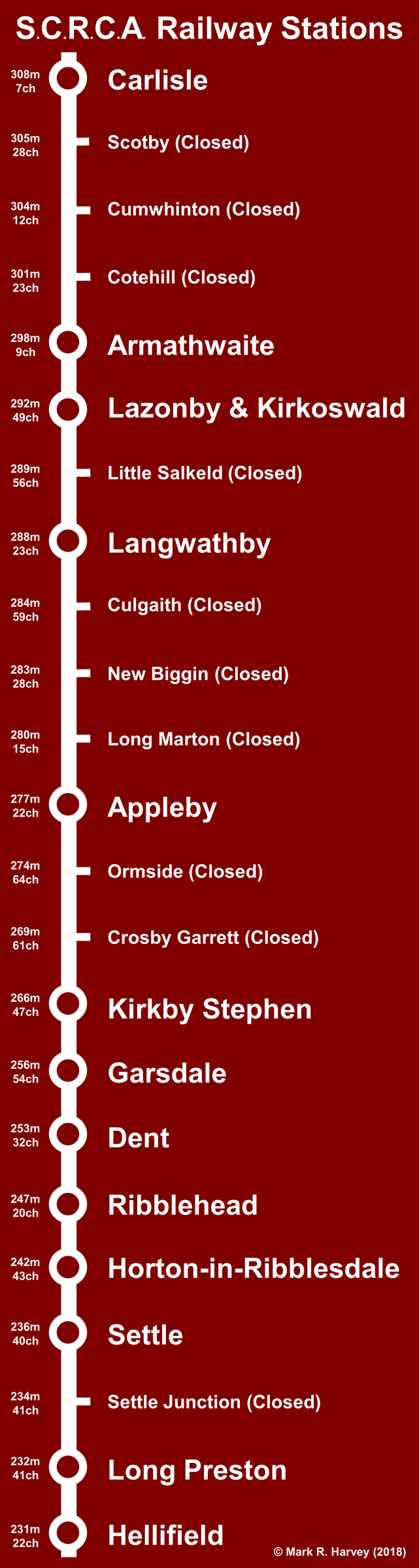
railway stations.
A railway station is a place where passenger trains stop (or used to stop prior to closure) in order to pick-up and set-down passengers. Within the SCRCA, each railway station also had adjacent or nearby facilities for handling goods (freight), although those at Carlisle were some distance away from the passenger facilities.
The diagram (see right or below) shows the relative position of the railway stations within the SCRCA. (To view a larger version, click / tap on the thumbnail.)
Many of the most characterful and interesting structures within the Settle Carlisle Railway Conservation Area (SCRCA) are clustered around - and are directly associated with - the railway stations. Each station associated with the SCRCA originally included at least one example of most (usually all) of the following location types:
- Passenger facilities:
- Goods (frieght) facilities:
Over the course of one and a half centuries, some of these structures have been modified or replaced with newer versions and some have been removed completely. However, a significant number have survived the passage of time in a relatively unaltered form.
View example locations
A non-natural body of water created by diverting and / or damming at least one river, stream or natural spring. For the purposes of the SCRCA Project, the only reservoirs listed are those that were created by a railway company specifically to provide a reliable supply of water for railway purposes (e.g. to supply a water tank or tank house).
For further information about these structures, see "The importance of water to steam-operated railways".
View example locations
For the purposes of the SCRCA Project, retaining walls are large masonry structures that stabilise and reinforce the sides of steep-sided cuttings and embankments. Retaining walls will only be included in the database if they match one or more of the following criteria:
- they are visible from a publicly accessible location,
- they are interesting (i.e. there is the potential for an associated article) and / or
- they are particularly impressive (in terms of their size and appearance).
View example locations
Sidings are relatively short stretches of track used to 'set-aside' trains and parts of trains from the main running lines. This is useful:
- to allow other trains to pass,
- to facilitate the loading or unloading of freight or passengers, and / or
- for the servicing / storage of locomotive and rolling stock.
For the purposes of the SCRCA Project, lie-by sidings, spurs, loops, headshunts, railway tracks in goods-yards and railway tracks in locomotive servicing areas are all classified as 'sidings'. Also, the term is used to indicate a single siding or a group of associated sidings: in other words, a 'siding' is any railway track that does NOT form one of the two main running-lines.
View example locations
Signs are only being being recorded or catalogued as part of the SCRCA Project if:
- they are especially interesting / noteworthy and if
- they can be photographed without trespassing.
View example locations
Signal boxes are essentially shelters constructed to house lever-frames and associated railway control equipment and to provide a degree of comfort for the human operators of that equipment. The lever-frames are used to operate points (more properly referred to as 'turnouts'), signals and level-crossing gates / barriers. For more information, please refer to the related article "What are railway signal boxes and why are they necessary?".
Signal boxes vary enormously in size, style and construction materials used, although many of the signal boxes within the SCRCA are timber-framed examples dating from the Midland Railway era (i.e. they were constructed during or before 1923).
View example locations
During severe winters, deep snowdrifts were a frequent cause of disruption on Britain's railway network. Within the SCRCA, Dentdale was particularly prone to drifting snow. In a bid to keep the snow off the tracks, a series of snow screens (also known as a snow fences) were erected in parallel lines along the upslope side of the railway. They were formed by up-ending sleepers and burying a portion of their length in the ground. Unfortunately, these structures proved to be totally ineffective and all that remains today are the skeletal remains of the more weather-resistant timber sleepers.
View example locations
For the purposes of the SCRCA Project, this is the main passenger-related building at railway stations - i.e. the building from which tickets are (or were) sold. In most cases, this building provided most of the facilities for passengers and most or all of the accommodation for station staff.
Please note that, with the exception of Settle, Appleby and Carlisle, these structures are now privately owned or leased and that they no longer provide 'booking' facilities (i.e ticket sales) for rail travellers. Passengers boarding a normal service train at one of the 'open' stations that has no ticket office can purchase a ticket on the train. For information regarding timetables, fares, ticket sales, etc., please refer to the National Rail Enquiries website at:
View example locations
The term 'station waiting room' has been applied to all secondary buildings that provide (or originally provided) shelter for passengers at railway stations, except where the building has - or originally had - 'booking' (i.e. ticket-selling) facilities. (Buildings that have or once had booking facilities have been classified as 'station main building and booking office'.)
View example locations
A structure labelled as a 'tank' on the 1911 landplan. (In most cases, it was probably a water tank.)
For further information about these structures, see "The importance of water to steam-operated railways".
View example locations
For the purposes of the SCRCA Project, a tank house is a large high-level watertight container with a usable room or space underneath. The container (i.e. the tank) is usually open-topped and designed to store water for railway use, often in association with lineside water cranes and / or water troughs.
For further information about these structures, see "The importance of water to steam-operated railways".
View example locations
Every tunnel within the SCRCA has a masonry-built portal or 'Tunnel Mouth' at each end. These structures form the entrances to / exits from the tunnel and they are designed to prevent landslips and rockfalls that could foul the running-lines (railway tracks) and cause an accident. Some 'Tunnel Mouth' structures include drainage channels to divert surface water away from the railway lines, thereby reducing the risk of flooding. Examples of the latter include Blea Moor Tunnel North Portal and Shotlock Tunnel South Portal.
For more information, please refer to the related article "What are railway tunnels and why are they necessary?".
View example locations
Turntables are used to turn railway locomotives around so that they do not need to run backwards for significant distances. This is especially important for mainline steam locomotives as these were not designed to run 'backwards' at speed or for long periods of time.
There are no intact turntables within the SCRCA. However, there are some surviving turntable pits and the latter have been classified as 'turntables' for the purposes of the SCRCA Project.
View example locations
Water cranes (also known as water columns) are located beside railway tracks and are used by train crews to quickly fill / refill the water tanks of steam locomotives.
For further information about these structures, see "The importance of water to steam-operated railways".
View example locations
A very long watertight (but open-topped) container fixed between the running rails of a railway line to allow the water tanks of passing steam locomotives to be filled quickly.
For further information about these structures, see "The importance of water to steam-operated railways".
View example locations
For the purposes of the SCRCA Project, this classification refers to historic built-in weighing scales that were installed and used at some locations to allow parcels and other small items of rail freight to be weighed (in order to calculate freight charges). This classification excludes the portable weighing devices that were used at almost all railway stations. It also excludes the large weighbridges associated with most Yard Offices.)
View example locations
The Midland Railway Company constructed temporary and permanent housing in a variety of sizes and styles specifically to accommodate its operational workforce. The availability of tied housing helped the company to attract and retain the people it needed to operate the railway system all year round. In the days before mass car ownership, it was important for people to have accommodation reasonably close to their place of work and this was especially important in more remote areas. Contemporary accounts suggest that the cottages were available to any of the Company's local employees (rather than being restricted to specific job roles). As an example, the 1876 edition of Wildman's Almanac (published in Settle) tells us that "At Settle new station ... Six cottages for signal-men, porters, etc., have been finished and are inhabited." and that "At Blea Moor there are .. two cottages for the use of signalmen and platelayers". Within the SCRCA, the most easily identifiable (and arguably the most attractive) examples of the permanent housing are the three 'standard' types that were built in 1875-6 during the final phase of the line's construction. This initial set of residential buildings were built by multiple independent contractors, but they share a set of common design characteristics that are similar to those found on the standard booking office buildings. As car ownership increased and the number of people needed to operate the railways declined, these tied houses were gradually sold off.
Please note that ALL of the former workers' houses are now privately owned. If you decide to view these structures in the real world, please respect the privacy of the occupants and DO NOT TRESPASS.
View example locations
Yard offices (also known as weigh houses) are small buildings that were used for the administration associated with operating a railway goods yard. The railway employees ('freight clerks') working in these yard offices would record all items of freight entering and leaving the yard.
In most cases within the SCRCA, yard offices also housed the measuring part of an adjacent weighbridge (i.e. a large weighing scale capable of weighing carts and other road vehicles, both with and without their loads). This allowed the clerks to calculate the weight of the freight that had been loaded or unloaded in the yard (hence the alternative name 'weigh house'). Freight charges were often based on a combination of the nature (type) of the item being carried and its weight, so the provision of a weighbridge enabled the clerks to calculate and levy the correct fees. In many cases, the railway companies would generate additional revenue by offering a weighing service to local businesses (e.g. coal merchants, feed merchants and farmers). At most railway stations, a set of weighing scales would also be provided to allow smaller items to be weighed accurately.
View example locations
|
Errors and omissions |