Glossary of Terms
This glossary covers some of the key terminology (jargon) associated with the Settle-Carlisle Railway Conservation Area (SCRCA) Project.
Architectural terminology has NOT yet been included as we are seeking a volunteer with the architectural knowledge / experience needed to undertake this task (see Creating formal descriptions of structures on the Getting Involved page).
Note: If you have JavaScript installed and enabled on your device, clicking / tapping on a term will hide /display the definitions.
A subjective assessment of how easy or difficult it is to reach the site or structure. EASY: Within half a mile of a public road, good walking conditions. MODERATE: 0.5 to 2 miles from a road. May involve uneven terrain and / or some ascent / descent. DIFFICULT: More than 2 miles from a public road. The terrain may be extremely rough with significant ascent / descent. NO ACCESS: Cannot be seen from a publicly accessible location. UNKOWN: Not yet been assessed.
View extended definition
How the assessment was conducted: On-site, Off-site using high-quality images, or Off-site using low-quality images.
View extended definition
Assessment Reports are used by some SCRCA Project volunteers to help prepare for field visits to sites or structures associated with the SCRCA and to record and communicate the information obtained during those field visits. (NB: The assessments conducted as part of the SCRCA Project are quick visual assessments only. They are NOT detailed structural or archaeological surveys and they must not be used or interpreted as such.)
View extended definition
The Assessment Report Status is used to control reviews and follow-up action. The valid categories are - New: recently uploaded, but not yet reviewed. Open: Reviewed, but follow-up action is required / desirable. Closed: Reviewed and no further action is required.
View extended definition
The condition of a structure at the time it was last assessed. The 'condition codes' used for the SCRCA Project are A = Good, B = Fair, C = Poor, D = Very Bad, E = Earthworks only, F = No trace, X = Assessment not possible and Z = Not assessed. For further information, please refer to the SCRCA Definitions: Condition Codes page.
The trend in the condition of the structure (Improving, Deteriorating, Stable, or Not assessed).
View extended definition
The period during which the site or structure was constructed, installed or created. The classifications used for the SCRCA Project are:
- 0: Unknown = The date / period of construction, installation or creation has not yet been ascertained.
- 1: Pre-69 = Prior to construction work commencing on the Settle-Carlisle line (prior to 1869)..
- 2: MR-C = Midland Railway construction phase (1869 to 31st December 1876).
- 3: MR-O = Midland Railway operational phase (1st January 1877 to 31st December 1922).
- 4: LMSR = London Midland Scottish Railway operational phase (1st January 1923 to 31st December 1947).
- 5: BR = British Railways operational phase (1st January 1948 to 31st December 1964) and British Rail operational phase (1st January 1965 to 31st March 1993).
- 6: Post-BR = After British Rail - includes Railtrack and Network Rail operational phases (1st April 1994 to present).
SCRCA Project Contributors are the people and / or organisations that have contributed material and / or information relating to the SCRCA Project. Typical examples of contributed material include images, reference documents and memories. A list of contributors is available on the Contributors (Acknowledgements) page.
How (for what purpose) the site or structure is currently being used. The classifications are explained briefly in the extended definition, but they are broadly self-explanatory: Agricultural, Commercial, Conserved, Demolished, Disused, Domestic, Museum, Railway ops, Relocated, Residential, or Unknown.
View extended definition
The default image for an SCRCA Project site or structure is assigned by the SCRCA Project Coordinator during the review process following each assessment. As a general rule, the default image will be the most attractive and most representative 'elevation' view available at the time of the review.
A comprehensive description of the structure's visual appearance (covering both design and materials) using standardised / approved Network Rail and Historic England vocabulary.
View extended definition
A subjective classification of photographic images based on a combination of the field of view and the vantage point. The values assigned to SCRCA Project images associated with SCRCA Locations (sites & structures) are Context, Detail, Elevation, Cab-view, Aerial and Photo-montage.
View extended definition
All listed buildings in England are assigned a unique reference number - known as a 'List Entry Number' - by Historic England. This reference can be used to find the relevant entry in "The National Heritage List for England (NHLE)" via the Historic England website.
View extended definition
Every site and structure in the SCRCA Project Database has been or will be assigned a unique six-digit "Location ID". The first three digits reflect the 'miles' component of the rail mileage. The remaining three digits reflect the APPROXIMATE location of the site or structure within that linear mile (relative to other nearby sites and structures).
View extended definition
Each location in the SCRCA Project Database has a Location Record. This contains the basic details of the site or structure, including its Location Type, Location Variant (where applicable), Assessment status, Current Use(s), depiction (or otherwise) on the MRC's 1911 landplan, Construction / installation period, the distance from London St.Pancras (in miles and chains), Visibility, Accessibility (ease of access) and Protection Category, plus details of its geographic position in a variety of formats. The information stored in these Location Records forms the core of the related Location Summaries.
A Location Summary is a consolidated and summarised view of all the currently available information relating to a single SCRCA location (site or structure). The Location Summary includes ALL of the key information from the base Location Record, plus links to all associated images and snippets (of additional information). The location summaries are best accessed via the Gazetteer, but some of them can also be accessed via the Virtual Visit and Heritage Hotspot pages.
For logged-in authorised users (i.e. SCRCA Project Team Members and SCRCA Project Guests), each Location Summary also includes summary details of (and a link to) all associated Assessment Reports.
The Location Type is used to classify SCRCA sites and structures based on their original purpose / function. For details of the various classifications, see Location 'types' with associated definitions.
The Location Variant is used to classify SCRCA sites and structures of a specific Location Type that share the same key characteristics (e.g. the official design for station buildings, signal boxes and workers' housing; the nature of the span for bridges; and the building materials used for the walls of platelayers' huts. For details of the various classifications, see Location 'variants' with associated definitions.
Examples of Primary Source Materials
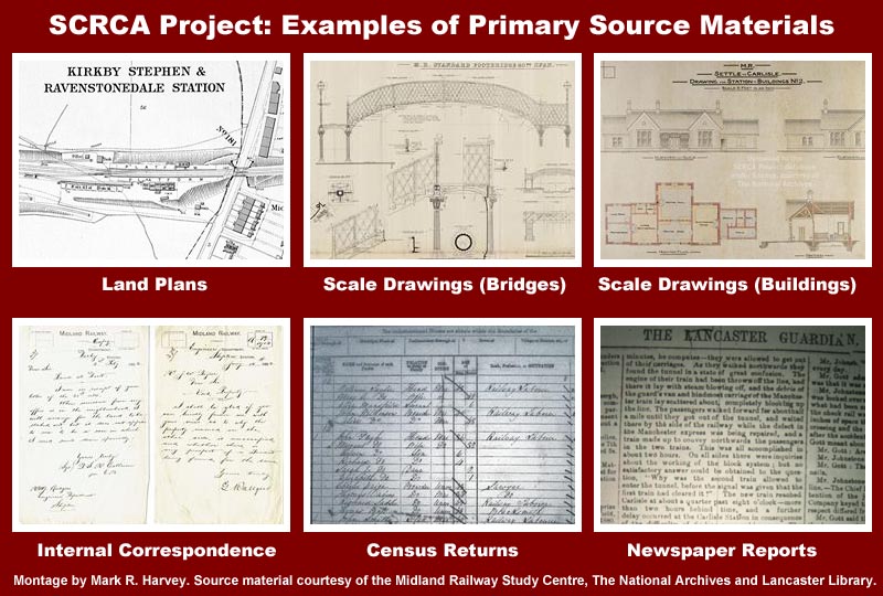
With respect to historical studies, a primary source is a record that was created at the time the event being described or otherwise recorded took place, or a record that was created shortly afterwards by someone who personally witnessed or participated in the event. For the purposes of the SCRCA Project, potentially useful / interesting historical primary source material is likely to include maps, land-plans, distance diagrams, construction drawings, engineer’s drawings, structural plans, Historic Environment Records, county, parish & census records, archaeological survey reports, photographs, film / video footage (including driver's eye view footage), aerial imagery (including LiDAR imagery and infra-red / visible spectrum photography), news reports, oral histories, physical artefacts in museums & private collections and, of course, physical structures such as historic buildings and bridges that still stand in the landscape. Modern-day primary sources include photographs taken and notes made during assessment visits carried out by SCRCA Project volunteers. For the purposes of the SCRCA Project, the terms primary sources and primary source material are effectively synonyms, although the latter tends to be used when the emphasis of a sentence needs to be placed on the physical material itself (e.g. the maps, photographs, etc) rather than the information contained in or conveyed by that material. See also Primary source material and contemporary accounts relating to the construction of the Settle-Carlisle Railway and secondary source.
In addition to their location within a designated conservation area, some of the sites and structures within the SCRCA benefit from additional protection such as scheduling, listing and local listing by Historic England. For details of the various categories, see SCRCA Definitions: Protection Categories.
The distance of the site or structure in miles and chains from London St Pancras (via the former Midland Railway Company's most direct route). The 'mile' values applicable to the SCRCA Project lie between 230 and 308 (inclusive) and they are rounded-down to the nearest whole mile.
View extended definition
The position of the site or structure relative to the main running lines (rail-tracks): Up, Down, Middle, Below, Above, Level-X, Remote.
View extended definition
With respect to historical studies, a secondary source is a record that was NOT created at the time the event being described or otherwise recorded took place or a record that was NOT created shortly afterwards by someone who personally witnessed or participated in the event. For the purposes of the SCRCA Project, potentially useful / interesting historical secondary sources are likely to include reference books and magazine / journal articles that are not contemporary with the period being described. The terms secondary sources and secondary source material are synonyms - i.e. they mean the same thing. See also primary source.
'SCRCA Sites' are:
- groups of related 'SCRCA Structures' such as those associated with a specific railway station, motive power depot or rail-served industry, or
- other locations that are relevant to the SCRCA, but are not structures (e.g. the locations of railway accidents).
See also:
'SCRCA Snippets' are items of background information relating to one or more of the locations (sites and / or structures) within or associated with the Settle-Carlisle Railway Conservation Area (SCRCA).
Snippet categories include:
- formal detailed descriptions of structures;
- knowledge bases (brief summaries of key facts and figures associated with a given location);
- extracts from, or summaries of, third-party primary and secondary reference-sources;
- the memories of specific individuals (in the form of oral histories); and
- general notes.
Each snippet is associated with all relevant site and / or structure records, which allows the snippet title to be automatically listed in all relevant Location Summaries. (Clicking / tapping the snippet title opens the full snippet.)
The Location Summaries can be accessed via the Virtual Visit, Gazetteer and Explore options.
Information of a more general nature is gradually being uploaded via a series of Articles.
'SCRCA Structures' are single descrete buildings and other structures that warrant an entry in the SCRCA Project database. See also:
How visible the site or structure is from the nearest public right of way or other publicly accessible location: Visible, Part-visible, Not visible, or Unknown.
View extended definition