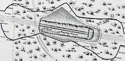
showing the location of Baron Wood Naptha Store.
A small structure, rectangular in plan and labelled 'Naptha Store', is clearly shown on sheet 82 of the 1911 set of Midland Railway Company 'land plans' - see extract, right or below. (Although the wording of the label is not clear on the photograph of the land plan, it is clearly readable on the 'original' document, which forms part of the FoSCL archive.)
This structure is located at the foot of the northeastern rock face, between the retaining wall and the 'Up' - i.e. southbound main running line), in the cutting between Baron Wood Tunnel No 1 (Bridge 315) and Baron Wood Tunnel No 2 (Bridge 316).
It is extremely likely (almost certain) that the stone-walled structure visible on this site today is what remains of the 'Naptha Store' marked on the land plan.
