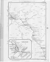
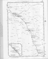
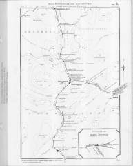
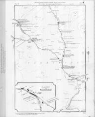
Distance diagrams are simplified maps drawn by railway companies to facilitate the calculation of distances between key locations such as passenger stations, goods yards and private sidings. They were used in conjunction with published distance tables and tariffs to calculate fares (for passenger journeys) and carriage charges (for parcels, livestock and other consignments of rail freight). They were also used for general reference purposes including asset management, permanent way maintenance, incident reporting, etc.
The distance diagrams produced by the Midland Railway Company were of exceptionally high cartographic quality and they were updated periodically to reflect network changes, name changes, re-mileaging exercises, etc. They are a fascinating resource and are especially valuable to modern-day researchers due to their clarity, accuracy and the amount of information that they contain.
The main diagrams were originally printed at a scale of one inch to the mile and they depict:
- the Company's routes in relation to
- key topographical features (such as rivers, hills and large country estates),
- significant settlements,
- the routes of other railway companies (where relevant), and
- county boundaries;
- the locations of stations, goods depots, Company sidings, private sidings, junctions, signal boxes, tunnels and viaducts; and
- the distances (in miles & chains) between adjacent locations and from London St Pancras (via the shortest route).
Inset enlargements (originally printed at two inches to the mile) are included for key locations and these are especially informative as they also provide simplified track layouts.
We have been fortunate to obtain permission to upload examples produced in 1913-1914 that cover the full extent of the Settle Carlisle Railway Conservation Area and these can be accessed via Figures 1 to 4 below [1].
Further Reading
See also "Settle-Carlisle Railway Mileposts" and "Railway land plans: Introduction and index".
Footnotes & Acknowledgements
Research and text by Mark R. Harvey (© Mark R. Harvey, 2022).
[1] The four digitised distance diagrams are reproduced here courtesy of the Midland Railway Study Centre (reference RFB20546) and they were derived from "L.M&S.R. Midland Division Diagrams, Copy No. 44". To speed-up downloading, they have been converted to greyscale and scaled to approximately 50% of their digitised size. The resulting images are subject to the Creative Commons Attribution-NonCommercial-ShareAlike 4.0 International License. We are grateful to Dave Harris (the Study Centre Coordinator) for making these documents available for SCRCA Project use.


