Getting the measure of things
Section 94 of the Railways' Clauses Act of 1845 requires that railway companies measure the length of their operational railway lines and install some kind of marker at quarter-mile intervals to denote these measured distances. The precise wording of the Act (which is still on the Statute Book) is as follows:
"Milestones. The company shall cause the length of the railway to be measured, and milestones, posts, or other conspicuous objects to be set up and maintained along the whole line thereof, at the distance of one quarter of a mile from each other, with numbers or marks inscribed thereon denoting such distances."
In addition to this statutory obligation, railway companies needed to measure distances, install distance-markers and produce distance tables / diagrams for a wide-range of operational reasons including:
- estimating speed (before the widespread introduction of speedometers in locomotive cabs);
- calculating tariffs and passenger fares;
- reporting the location of faults, breakdowns, etc; and
- allocating 'lengths' of track to specific 'gangs' of permanent-way workers.
To meet these statutory and operational requirements, the Midland Railway Company measured each new line as it was being built. A series of markers were then installed at quarter-mile intervals along the full length of the new line, each marker denoting the distance from the new line's 'zero-point' (usually a major station or a junction with an existing line). This resulted in dozens of 'zero points' across the Midland Railway Company's network and the original 'zero point' for the Settle-Carlisle line was Settle Junction.
From time to time, new railway-related structures were added, existing structures were moved or demolished and, occasionally, new routes were opened. All of these changes required some form of re-measurement and the subsequent alteration of existing documentation. On October 17th 1890, in a bid to help speed-up the re-measurement process, the Midland Railway Company's Board of Directors formally accepted a recommendation from the Traffic Committee "that a Guards Van be fitted up with an apparatus for measuring distances at an estimated cost of £85"1.
During the late 1890s2, for reasons that have not yet been identified from primary sources, the Midland Railway Company launched a project to re-measure and re-mileage their entire network, including their main line from London to Carlisle. For reasons that are also unclear, it was decided that all routes north from the capital would be measured from a common zero point, namely the buffer stops at London St. Pancras. The re-mileaging process for the Skipton to Appleby section of the route is partly documented in a series of four Midland Railway Company internal memoranda3. Facsimiles of these remarkable survivals are reproduced below, alongside full transcripts of their text.
Tip: Clicking / tapping on any of the images in this article will open a larger version of that image.
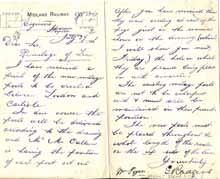 This document facsimile is licensed under a Creative Commons Attribution-NonCommercial-ShareAlike 4.0 International License. See footnote 3 for attribution. |
Midland Railway Engineer’s Department, Skipton Station July 27, 1901 Dear Sir, Remileage of Line I have received a print of the new mileage posts to be erected between London and Carlisle. In due course the posts will be delivered according to the drawing and Mr McCallum4 is having the position of each post set out. After you receive them they want erecting at each of the pegs just in the manner shown on the drawing5 (which I will show you next Friday) the hole in which they are placed being filled with concrete. The existing mileage posts are not to be interfered with and must still be maintained in their present position. The new posts must be placed throughout the whole length of the route on the up side of the line. Yours truly, |
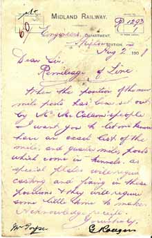 This document facsimile is licensed under a Creative Commons Attribution-NonCommercial-ShareAlike 4.0 International License. See footnote 3 for attribution. |
Midland Railway Engineer’s Department, Skipton Station Dear sir, Remileage of Line When the position of the new mileposts has been set out by Mr McCallum's people I want you to let me Acknowledge receipt. Yours truly |
|
|
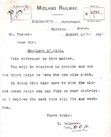
Midland Railway Engineer’s Department, Skipton Station Mr. Poyser7 Dear Sir, Remileage of Line With reference to this matter. You will be required to provide and cut the short rails to form the new mileposts. In doing this take care to pick the oldest scrap rails you can find on your district, as I believe the cast tops will fit any section. Yours truly, |
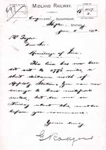 This document facsimile is licensed under a Creative Commons Attribution-NonCommercial-ShareAlike 4.0 International License. See footnote 3 for attribution. |
Midland Railway Engineer’s Department, Skipton Mr. Poyser Dear Sir, Remileage of Line The line has now been set out to 277½ miles, a short distance north of Appleby station. You can now arrange to have mile posts erected, but see me on Friday about the matter before you commence. Yours truly, |
The dates of these four internal memoranda clearly indicate that the planning and preparatory works for re-mileaging the Skipton to Appleby section were being carried-out during 1901-2 and that the position of the new mileposts for this section had been marked-out by June 11th 1902. Unfortunately, we do not (so far) have any documentary evidence to indicate when the new mileposts were actually installed. However, the tone of the memoranda from G. Rodgers suggest that he was expecting it to be done without undue delay, probably during the Summer / Autumn of 1902. This is significantly earlier than the dates of 1907 and 1914 suggested by Gough8 and Anderson & Fox9 respectively, although the latter may refer to the following entry in Signalling Alterations Book No. 5: "Remilage of the Line - All the old Mile Posts removed. June 1914"10.
A general insight into the re-measurement process is provided in a handwritten entry on the fly-leaf of Signal Alterations Book No.111 (see below), although it should be noted that this does not apply specifically to the Settle-Carlisle Line. Also, for the reasons explained in footnote 12, the dates that are given in this source should be treated with caution, especially the date of 1906 given for re-mileaging.
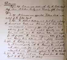 This document facsimile is licensed under a Creative Commons Attribution-NonCommercial-ShareAlike 4.0 International License. See footnote 11 for attribution and footnote 12 for information regarding the probable author of these handwritten notes and comments regarding the reliability of the information provided. |
Distances. Before 1891. Distances were dealt with by the Estate Agent's Staff, Messrs McCallum, Lewty, and Dudenly [Dudeney], of the Drawing Office. In 1891. Mr Simmons was appointed Distance Clerk under control of the Estate Agent. In 1892. The Midland Railway, and Joint Lines including the Somerset and Dorset, and Midland and G.N. Joint Lines were remeasured, a measuring apparatus fixed in an ordinary guards van, and worked specially over the line, was used, and the distances taken were adopted for all purposes. The distance diagrams, tables of lengths, and Clearing House distances, were completely reissued. In 190612. The Railway was again remiled, for new mile posts, by Mr Simmons13, partly with the Measuring Van, and partly with chain, wooden pegs were placed at each quarter of a mile In 1923. The distance work was transferred from the Estate Agent to the Engineer (Mr Miles). |
Clearly excellent by design
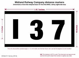
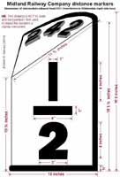
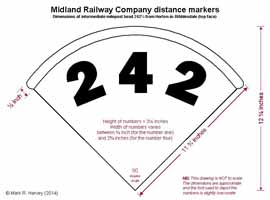
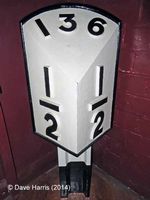
Two standard designs were used for the milepost heads installed throughout the Midland Railway Company's network during this re-mileaging exercise: one for the full mile markers, the other for the intermediate (quarter, half and three-quarter mile) markers. On the network as a whole, there were two variants of the full-mile marker: one for miles 0 to 9 (the faces of which were 1ft 2in wide), the other for miles 10 and above (the faces of which were 1ft 7in wide). However, on the Skipton-Settle-Carlisle section, only the larger variant was needed as all the mileages are three-figure numbers. Although the official technical drawing referred to in the July 27th 1901 memorandum does not appear to have survived, a later version (drawn in 1908) was reproduced on page 78 of 'Midland Record', Issue No. 15 as part of a short article dealing with Midland Railway lineside structures14. Unfortunately, the whereabouts of the original 1908 drawing is currently unknown and the reduced-size version from the article cannot be reproduced here at the present time for copyright reasons. In lieu of these official drawings, the line-drawings below show dimensions for the two designs based on measurements taken from accessible examples. The main design features are also illustrated by a series of colour photographs later in this article.
The Midland Railway Company's standard design for mileposts
All of the variants would almost certainly have been cast in sand moulds15 created using wooden patterns16 and it is probable (although by no means certain) that the casting work was carried-out in the "Chair Foundry" at Derby Locomotive Works17.
Hints of the method used for adding numbers to milepost head patterns
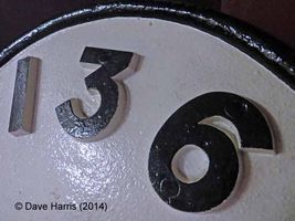
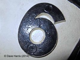
A close examination of the example on display in Derby's Industrial Museum18 reveals evidence of the pattern-creation process (see the Milepost Design - Images 4, 5 and 6 below). Note the circles at the top and bottom of each number (they are most visible on the number six). These are probably an impression of pegs used to temporarily fix patterns for the individual numbers onto a standard head pattern prior to moulding. This pattern design would have allowed each head pattern to be used for a wide range of number variants, although different head patterns would have been needed for 1 digit, two digit and three digit mileages.
Once cast, each milepost head would have required 'finishing' - i.e. grinding (to remove unwanted metal sprues and to smooth-off the surface), followed by de-greasing, priming and painting. With regards the latter, the technical drawing from 190814 includes the following instructions: "All to be painted 3 coats white lead paint as specified, letters, figures and beading in black." (Note: from 1963 onwards, mileposts on Britain's railway network were generally re-painted yellow with black numbers in order to improve their visibility in snow and fog. This is why most of the examples visible today are black on yellow rather than black on white.)
The design-criteria used by the Midland Railway Company when developing these milepost heads have not (so far) been ascertained from primary sources. However, they will almost certainly have included:
- Ease of manufacture
- Ease of installation
- Durability
- Low-maintenance
- Low cost
- Visibility
In terms of all these criteria, the Midland Railway Company's standard design must rank among the best on the UK's rail network (past or present) - especially with regard to durability and visibility from the footplate or driver's cab - and this is undoubtedly why so many of them have survived in situ for well over a century. The SCRCA Project19 database includes 305 distance-marker sites (15 between Hellifield and Settle Junction, 290 between Settle Junction and Petterill Junction). Cab-view video footage filmed in 2012 shows that at least 265 (86%) of these sites have retained a milepost / distance-marker dating from the Midland-Railway Company era.
Fixtures and fittings included
(The methods used for fixing distance marker heads to posts and walls)
The main castings for both variants of the standard milepost head include an integral two-bolt fixing 'seat' at the rear (see photos below). This strengthens the head and allows it to be easily bolted onto a pre-drilled post (made from a short length of old rail) or a wall-bracket.
Photo 4
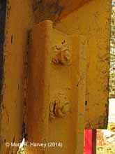
Note the two cast-in fixing bolts protruding through pre-drilled holes in the post and the corresponding securing nuts.
(Structure ID 242500).
Photo 5
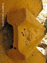
Note the integral 'seat' cast into the head and the cast-in fixing bolts protruding through pre- drilled holes in the post.
(Structure ID 242500).
Photo 6
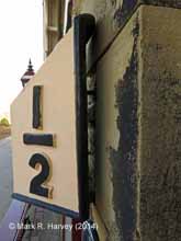
A single-piece wall bracket has been set into the wall and the head has been fixed onto it using the cast-in bolts.
(Structure ID 236500).
Photo 7
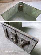
(These are visible at the top-left of the lower photo of this full-mile head20 at the MRSC in Derby.
Variations on a theme
(Examples of the Midland Railway Company's standard design for mileposts)
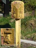
The photographs below (drawn from the SCRCA Project database) show examples of the quarter mile, half mile, three-quarter mile and full mile variants of the Midland Railway Company's standard designs for milepost heads.
Photo 8
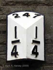
Milepost 247¼ is mounted on the wall of the restored former booking office at Ribblehead. It has been painted white to reflect standard Midland Railway Co. practice.
Photo 9
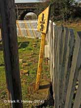
Milepost 232½ illustrates how the 8' long posts (10' long on embankments) were set into concrete and inclined at a 3.75 degree angle (leaning away from the tracks).
Photo 10
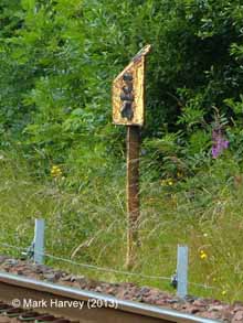
Milepost 284¾ illustrates the typical positioning adjacent to the tracks on the 'Up' side, originally 7'9" from the nearest rail (7'0" on embankments).
Photo 11
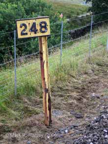
Milepost 248 illustrates how old rail was used to create the posts. Originally, the bottom edge of the head casting would have been 3'0" above the top of the nearest rail (4'6" on embankments).
For photographs of additional examples, see the Structure Type Definition for Mileposts.
If you would like to inspect examples yourself, you can do so safely at the following locations within the SCRCA:
| Location | Mileage | Structure ID | Notes |
|---|---|---|---|
| Long Preston Station | 232½ | 232500 | Post-mounted on the 'Up' platform, close to the front of a flower bed). |
| Settle Station | 236½ | 236500 | Attached to the rail-facing wall of the former booking office. |
| Horton-in-Ribblesdale Station | 242½ | 242500 | Post-mounted on the 'Up' platform, close to the front of a flower bed). |
| Ribblehead Station | 247¼ | 247250 | Attached to the rail-facing wall of the former booking office. |
| Appleby Station | 277¼ | 277250 | Post-mounted on the 'Up' platform, close to the front of a flower bed). |
NB: These structures form an integral part of the operational railway. DO NOT TAMPER OR INTERFERE WITH THEM. Please respect the flower beds in which they are located and the buildings to which they are attached.
Alternatively, you may wish to arrange a visit to the Silk Mill Museum21 (Derby's Industrial Museum) and inspect the examples in their collection.
The writing may be on the wall
The internal memorandum dated August 2nd 1901 indicates that wall-plates (rather than posts with heads) were to be used for distance markers inside tunnels. In theory, this would apply at eighteen locations within the SCRCA:
| Tunnel | Distance marker |
|---|---|
| Stainforth | None |
| Blea Moor | 249½, 249¾, 250, 250¼, 250½, 250¾ |
| Rise Hill | 254¼, 254½, 254¾ |
| Moorcock | 257½ |
| Shotlock | 258½ |
| Birkett | 264½ |
| Crosby Garrett | 269 |
| Helm | 273¼ |
| Culgaith | 285, 285¼ |
| Wastebank | None |
| Lazonby | None |
| Baron Woods No. 1 | None |
| Baron Woods No. 2 | 295¾ |
|
Armathwaite |
296¾ |
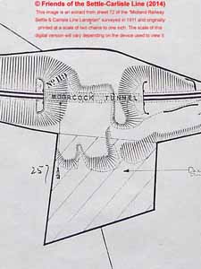
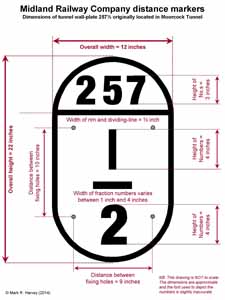
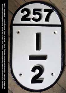
There is no public access to these tunnels, so it is not known if any of the wall-plates remain in-situ. However, it is known that the 257½ mile wall-plate from Moorcock Tunnel was removed at some point in time as it now resides at the Midland Railway Study Centre in Derby (see Figures 4 & 5 and Photo 12 below).
The 257½ mile wall-plate from Moorcock Tunnel
Photo 12
The shortest route
All Midland Railway Company distance diagrams produced after the remileaging exercise (including those reproduced by the Cumbrian Railways Association23) include the following statement:
"The continuous Distances are from St PANCRAS PASSENGER STATION by the Shortest Route and represent the milepost mileage."
At the time these diagrams were drawn, there were several different Midland Railway Company route options for trains travelling north-south between London St. Pancras and Settle Junction. Each of these route options would result in a different starting mileage for the Settle-Carlisle line, which begs the question "What was the shortest route?". In 2009, the author posed this question to the volunteers at the Midland Railway Study Centre and Dave Harris kindly used the centre's historic sources to identify the precise route used for the calculation:
"Milepost 0 was at the buffer stops at St. Pancras. From there, the shortest route is simple enough travelling north along the mainline via Leicester (99m 6c). At Trent Junction (119m 19c) the shortest route is via Toton and the Erewash Valley. North of Chesterfield (146m 20c) the shortest route diverges onto "The Old Road" at Tapton Junction (146m 69c), bypassing Sheffield, re-emerging at Rotherham Masboro (162m 0c). Northwards via Swinton (167m 9c), Darfield (171m 28c), Cudworth (175m 8c), Normanton (185m 11c) to Methley Jn (187m 34c). At Leeds, bypassing Wellington Station (196m 1c), the shortest route runs between Engine Shed Jn (195m 20c) and Whitehall Jn (195m 54c). Thereafter the route runs, as today, via Kirkstall (198m 24c), Shipley (Leeds Jn 205m 60c - Bingley Jn 206m 1c), Keighley (212m 6c), Skipton (221m 21c) to Settle Jn (234m 41c). Finally, the end of Midland metals at Petteril Jn, Carlisle is 307m 14c."
Mixing one's mileages
The memorandum dated June 11th 1902 states that the location of the new mileposts between Hellifield and Appleby had been pegged-out by this date. However, it is interesting to note that the 1911 and 1912 land plans for the Settle-Carlisle line still show both the old and new mileages. This is evidenced by the extract from the 1911 land plan for Langwathby station (see Figure 6 below). This extract was chosen because an indicator of the old mileage (measured from Settle Junction) is still visible here today: the number 53½ (see photo 13 below) is visible on the 'down' side, painted near the base of the rail-facing wall of the former booking office, immediately to the left of the porch doors. The nearest mile-marker dating from the re-mileaging exercise (milepost 288¼, measured from London St. Pancras) is located on the 'up' side at the south end of the 'up' platform (see photo 14 below).
Figure 6
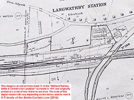
Photo 13
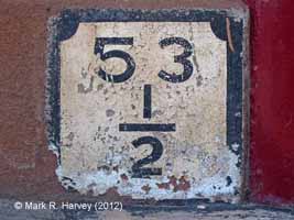
Photo 14
A few 'ups' and 'downs'
The memorandum dated July 27th 1901 clearly states that the new mileposts were to be installed on the 'up' side of the line and this is where they are depicted on the 1911 and 1912 land plans. In contrast, the land plans depict the majority of the original mileposts on the 'down' side, with just a few on the 'up' side. A review of cab-view footage shot between Hellifield and Carlisle at various dates between 1984 and 2012 suggests that the 'up' side instruction was fully implemented for the new mileposts within the SCRCA. There is currently one exception: milepost 290¾ (Structure ID 290750) has been located on the 'down' side since at least 1984. However, it is almost certain that this was originally located on the 'up' side, but relocated to the 'down' side in the 1950s to facilitate the extensive remodelling of Long Meg Sidings.
A note of caution . . .
Conducting detailed historical research is rarely as straightforward as one might like. Contemporary records rarely survive in a complete and easily accessible form and the records for the Settle-Carlisle Railway are no exception to this general rule. Some key documents (or parts of documents) will have been destroyed. Others lie hidden in dark and dusty corners, awaiting a surprise discovery at some point in the future. Many of the surviving records are stored in public archives and private collections, where they cannot be easily accessed. Where catalogues and indices have been created, they often contain errors and omissions. To make things even more challenging, one contemporary source often contradicts another. All this is a long-winded way of stating that this article should not be treated as the final word on the subject of Settle-Carlisle Railway mileposts or the associated re-mileaging exercise. On the contrary, research into this subject is ongoing and it is quite possible that new sources will be found, some of which may force a re-interpretation of material presented in this article.
. . . and a plea for information
If you have any information that might help us to fill-in gaps and / or correct errors in this article, we would love to hear from you via the SCRCA Project's dedicated 'Contact Us' form.
Further reading
If you would like to learn more about railway mileposts, you may find the following of interest:
- A detailed but general introduction to the subject of railway distance markers (including mileposts) is available online in "Section 28: Distance Markers" of the "Railway Signs and Signals of Great Britain" website - see: https://www.railsigns.uk/sect28page1.html
- An essay by John Gough (Chairman of the Midland Railway Society and author of "The Midland Railway : a chronology") entitled "Midland Railway Mile Posts" - is available online at: https://www.midlandrailway.org.uk/occasional-papers/midland-mile-posts/
Footnotes
- Source: Rail 491/26 Board Minutes 5015 3/7/1890 - 6264 20/6/1895. The quote is extracted from Board Minute No. 5082 (17/10/1890): "FITTING UP GUARDS VAN FOR MEASURING DISTANCES. Referring to Traffic Committee minute No.26711 it was Resolved That the recommendation of the Traffic Committee embodied in that minute be approved and that a Guards Van be fitted up with an apparatus for measuring distances at an estimated cost of £85."
- Date of decision to re-mileage: The exact date of the Midland Railway Company's decision to re-measure and re-mark the mileages across their entire network has not yet been ascertained definitively from primary sources, despite extensive research over many years by several members of the Midland Railway Society (MRS). MRS member Tony Overton offered this on the subject: "Although the W & W minutes have a lot to say about the measuring and surveying of the system from 1872 to 1923 I have not as yet found a single minute in any Committee minute book which proposes and authorises the remileaging of the Midland system. I find this very odd." In the absence of a definitive date, the approximate date stated here is based on information from two sources:
- A: The following entry in Signal Alterations Book 3 (Midland Railway Study Centre reference RFBMCT11338): "Re-mile posting the Midland Railway commenced in 1900 J.W.S." [Note: the initials are thought be a transposition error, referring in actuality to F.W. Simmons (the Distance Diagram Clerk).]
- B: A reference made by the locomotive historian Ahrons (writing in 1916*) in which he notes that the Midland Railway Company's main line was re-measured "about 18 years ago". [* Originally written in 1916 and published in the Railway Magazine as one of a long-running series of articles written by Ahrons between 1915 and 1926 under the series title "Locomotive & Train Working in the latter part of the Nineteenth Century". Subsequently included in Volume Two of a six-volume set - the entire set being published posthumously by W. Heffer between 1951 and 1954. The full reference for the later publication is Ahrons, E.F.: "Locomotive & Train Working in the latter part of the Nineteenth Century", published by W. Heffer in 1953, volume 2, page 89.]
- Midland Railway Company internal memoranda: These documents were originally donated to the Friends of the Settle-Carlisle Line but, to maximise their accessibility and availability to researchers, they were forwarded to the Midland Railway Study Centre (MRSC) in Derby where they now form part of the Roy F. Burrows Midland Collection (item reference RFBMCT27609). The facsimiles used here are straightened, cropped, reduced-size low-resolution versions of digital images kindly supplied by Dave Harris of the MRSC. They are licensed under a Creative Commons Attribution-NonCommercial-ShareAlike 4.0 International License. Full details of this license are available at: https://creativecommons.org/licenses/by-nc-sa/4.0/
- Mr McCallum: This is probably Peter Service McCallum (generally referred to as P. S. McCallum) who, in the 1901 census gave his occupation as 'Estate Agent (Midland Railway)' and his residence as '139 Osmaston Road, Derby'. However, it is just possible that the references in the memoranda refer to his son Robert Towson McCallum of the same address. No link with the Skipton - Settle - Appleby - Carlisle area has so far been identified for either of these individuals. However, no likely alternatives have so far been identified from extensive searches of primary sources. Furthermore, it is quite likely that a person responsible for and / or undertaking skilled surveying activities would have been based at the Company Headquarters in Derby. The task of surveying the SCR to lay-out pegs marking the locations for new mileposts could possibly be categorised as 'New Works' (which would favour Robert Towson McCallum). However, as the Company's Estate Agent, Peter Service McCallum (Robert Towson's father) had both the responsibility and the primary need to obtain and maintain accurate land plans and doing so would have required at least one detailed and accurate survey to be undertaken. The front-sheets for the 1911 and 1912 Settle-Carlisle Railway land plans include the following statement: "Surveyed by P. S. McCallum, Estate Agent, Derby, 1911" and "Surveyed by P. S. McCallum, Estate Agent, Derby, 1912" respectively. Based on the information available to date, it is the consensus of the author and those collaborating on this article that Peter Service McCallum was the driving force behind the Midland Railway Company's re-mileaging exercise generally and that he is the Mr McCallum referred to in the memoranda. This is supported by the following information and analysis kindly supplied by Tony Overton (a member of the Midland Railway Society who has spent a considerable number of years researching the Midland Railway Company and its personnel):
"The W & W Minutes record that McCallum had been appointed in 1873 to work in Mr Gratton's office (the then Land Agent, later retitled as Estate Agent) specifically to "revise land plans" - specific work authorised the previous year. The revision work was however not followed through. In additional to McCallum other staff had also been appointed to assist with the revision, but due to an increase in work in the office generally, they were put on ordinary work, and no attempt was made to proceed with the work that they had been appointed to deal with. In 1889 McCallum succeeded Gratton as 'Estate Agent'. No sooner is he in charge than he asks for and gets additional staff for his department. Then in Feb. 1891 McCallum highlights (minuted) the situation with regard to the 1872 revision work, asks for and gets more additional staff, and is given permission to proceed at once with the (1872) revision work.
". . . my list of re issuing dates for each Distance Diagram sheet shows virtually every one in use at that time as having being completely reissued in 1893 i.e. a new page as opposed to the annual list of alterations issued for the 'users' to make themselves."
". . . The above work however is to my mind purely getting, and keeping, distance diagrams, tables of length, and Railway Clearing House distance tables, up to date, along with the creation of a register of the Company’s property. I think the remileaging comes out of this work and is then carried out later."
-
Drawing referred to in the memorandum: Unfortunately, the drawing referred to in the memorandum dated July 27th, 1901 does not appear to have survived. The 1908 drawing referred-to in footnote 14 includes positioning and installation details, although the requirements in 1901/2 may have been slightly different.
-
G Rodgers: This is almost certainly George Rodgers who, in the 1901 census gave his occupation as 'Superintendent, Midland Railway, Way & Works Dept.' and his residence as '25 Calton Terrace, Carleton Road, Skipton, Yorkshire'.
-
Mr. Poyser: This is almost certainly Joseph William Poyser who, in the 1901 census gave his occupation as a 'Railway Engineering Inspector' and his residence as '24 Station Lane, Chesterfield'. (The address need not give cause for concern as the Midland Railway Company's senior employees were often relocated from one part of the network to another. The date of the 1901 census was the night of March 31st 1901; the date of the first memorandum to Mr Poyser in Settle is July 27th, 1901; and a Joseph William Poyser is listed on the 1904 Electoral Register as being resident in 'Railway Cottage, Settle'.)
- Source: Gough, John: "Midland Railway Mile Posts" (op. cit.) - In paragraph 4, Gough suggests 1907 as the date of the Midland Railway Company's network-wide re-mileaging exercise.
- Source: Anderson, V.R. & Fox, G.K.: "Stations & structures of the Settle & Carlisle Railway", Oxford Publishing Company (1986) - Anderson & Fox mention 1914 as the date of the re-mileaging exercise for the Settle-Carlisle line on several occasions in this book, including the note below the distance diagrams and the text accompanying Plate 1.
- Source: Page 65 of "Signalling Alterations Book No. 5 (1907 - 1918)", which forms part of the Roy F. Burrows Midland Collection (item reference RFBMCT13340) held at the Midland Railway Study Centre (MRSC) in Derby.
- Source: "Signalling Alterations Book No.1 (1890 to 1893)", which forms part of the Roy F. Burrows collection (item ref. RFBMCT11336) held at the Midland Railway Study Centre in Derby. The facsimile used here is a cropped, reduced-size low-resolution version of a digital image kindly supplied by Dave Harris of the MRSC. It is licensed under a Creative Commons Attribution-NonCommercial-ShareAlike 4.0 International License. Full details of this license are available at: https://creativecommons.org/licenses/by-nc-sa/4.0/
- Note regarding re-mileaging in 1906: Although Signal Alterations Book No.1 covers the period 1890 to 1893, the note on the fly-leaf must have been written significantly later than this. A comparison of the handwriting characteristics with other sources suggest that the note was written by Frederick William Simmons and the colour and density of the ink suggest that it was all written at the same time. The years mentioned range from 1891 to 1923, a span of 32 years. This, plus the lack of precise dates suggests that the note was probably written from memory during 1923 or later (by which time Mr Simmons would have been at least sixty years old). All of the information presented in the fly-leaf note has been verified in general terms using other reliable sources, although the dates given are vague and, in some cases, demonstrably inaccurate. Caution must therefore be adopted when using the date information from this source. In particular, the statement that "In 1906. The Railway was again remiled, for new mile posts" should not be taken too literally. The Midland Railway Company's network was re-measured on numerous occasions and it is known from a range of primary and other contemporary sources (many of which are quoted elsewhere in this article) that the entire Midland network was re-mileaged at least once. However, no primary source evidence has so far emerged to suggest that the Settle-Carlisle line was re-mileaged more than once. Furthermore, given the size of the network, it is perfectly possible that at least one part of it was re-mileaged in 1906 and this could account for the year given in Mr Simmons note. With regard to the re-mileaging of the Settle-Carlisle line, it is the consensus of the author and those collaborating on this article that the four internal memoranda offer a significantly more reliable source of dating information than the fly-leaf note.
- Mr Simmons: This almost certainly refers to Frederick William Simmons.
- Source: Reference: Essery, Bob: "M.R. Lineside mileage posts, gradient posts and cast iron notice plates" in 'Midland Record', Issue No. 15, published by the Midland Railway Society in 2001, pp77-79. The technical drawing appears on page 78 and it is titled "Midland Railway Mileage and Gradient Posts": it was produced by the M.R. Engineers Dept in July 1908. Unfortunately, this issue of 'Midland Record' is out of print, although copies do turn-up from time to time on the second-hand market.
- Sand-moulds: A brief overview of the sand casting process is available at: https://en.wikipedia.org/wiki/Sand_casting and a fascinating set of short educational video clips are available at https://www.facebook.com/foundry101/videos, (courtesy of Lost & Foundry).
- Wooden patterns: A brief overview of the pattern-making process for sand casting is available at: https://en.wikipedia.org/wiki/Pattern_(casting)
- Where were the milepost heads cast?: The Midland Railway had around 1,500 route miles and fulfilling an order for approximately 6,000 castings would have been a substantial - and costly - undertaking. The Permanent Way department had its own "Chair Foundry" at Derby Locomotive Works and this was used this to cast the chairs used to fix rails to sleepers. There was no foundry at the Signal Works and it is considered unlikely that milepost heads or similar would have been cast at the Carriage Works. Derby loco works is therefore considered to be the most likely in-house source for the new milepost head castings, although it is possible that the work was put-out to tender. Hopefully, future research will be able to shed some light on this subject and one avenue of research that has not yet been explored is a review of the Locomotive Works order books. These records have survived and they are stored at the National Railway Museum in York. However, these books contain huge volumes of material and there is no index, so reviewing them will be an extremely time-consuming process.
- Milepost 136½ in Derby's Industrial Museum: This complete milepost was originally located on the Pye Bridge Branch (near Ambergate in Derbyshire), close to the former Pentrich Colliery Sidings signal box. It is now on display at the Silk Mill Museum, Derby (see footnote 21 below). The three photographs of this milepost were kindly supplied by Dave Harris and they are used here with his permission.
- SCRCA: SCRCA is an abbreviation for the Settle-Carlisle Railway Conservation Area. The 78-mile section of railway between Hellifield Junction (two miles south of Settle) and Petteril Bridge Junction (one mile south-east of Carlisle), was designated a Conservation Area in 1991 due to its special architectural and historical interest. The conservation area was subsequently extended to include Carlisle Citadel station.The objective is to preserve the character and appearance of the railway (and the landscape through which it runs) without unnecessarily hindering the line's primary function as an important part of the national rail network.
- Milepost head 137 at the MRSC: This milepost head was originally installed on the Pye Bridge Branch, near Ambergate in Derbyshire. It now resides at the Midland Railway Study Centre which is located in the Museum of Making, Derby (see footnote 21 below). The two photographs used to create this composite image were kindly supplied by Dave Harris and they are used here with his permission.
- Museum of Making (a.k.a. the Silk Mill, Derby): This is Derby's Industrial Museum. For details of the museum’s location, opening times, etc - see https://www.derbymuseums.org/museum-of-making/visit/).
- 257½ mile tunnel wall-plate: This wall-plate was originally located in Moorcock Tunnel, but it was removed at an unknown point in time (for reasons that are also unknown) and it now resides at the Midland Railway Study Centre, which is located in the Silk Mill Museum, Derby (see footnote 21 above). The photograph was kindly supplied by Dave Harris and it is used here with his permission.
- Source: “The Midland’s Settle & Carlisle Distance Diagrams”, published by The Cumbrian Railways Association (1992). The dates of the diagrams that relate to the SCRCA range from 1913 to 1920 inclusive.
Acknowledgements
Text written by Mark R. Harvey (© Mark R. Harvey, 2014). Photographs supplied by Mark R. Harvey and Dave Harris (© as marked). Digitised versions of Midland Railway Company memoranda (item ref RFBMCT27609) and the fly-leaf from Signalling Alterations Book No.1 (item ref RFBMCT11336) supplied from the Roy F. Burrows Collection by the Midland Railway Study Centre and used here with permission. Extract from sheets 31 & 72 of the 1911 Midland Railway Company land plan digitised (as part of the SCRCA Project) by Mark Harvey and Nigel Musset from the paper version in the collection of the Friends of the Settle-Carlisle Line.
This article is the result of a collaboration between the author and the following individuals:
- Dave Harris (the Study Centre Co-ordinator for the Midland Railway Study Centre in Derby and Secretary of the Midland Railway Society).
- Nigel Mussett (the Archivist, Historian & Librarian for the Friends of the Settle-Carlisle Line).
- Roger Newman (a member of the Midland Railway Society).
- Tony Overton (a member of the Midland Railway Society).
- Peter Witts (the Information Officer for the Midland Railway Society).
The author gratefully acknowledges the information and assistance received from all of these individuals. Without their help and support, this article could not have been written.

