When alighting at Garsdale for the first time, a 21st century urban dweller might reasonably wonder why anyone would build a railway station in such a remote and lightly populated area. Aside from the structures associated with the railway, the only signs of human settlement appear to be a few scattered houses & barns and an isolated chapel. There are no industrial-scale mills or factories nearby and the closest towns are Hawes (7 miles by road), Sedbergh (10 miles) & Kirkby Stephen (13 miles). The reason lies in a combination of geography (1), railway history (2) and railway operations (3).
1: Garsdale Head lies at the intersection of two major river valleys (Garsdale and Wensleydale). At just 332 metres / 1,089 feet above mean sea level, this pass provides a relatively low-level east-west route through the Pennine hills. The pass was exploited by the Sedbergh-Askrigg turnpike in 1761-2 and it is still used by the current A684 (and the railway).
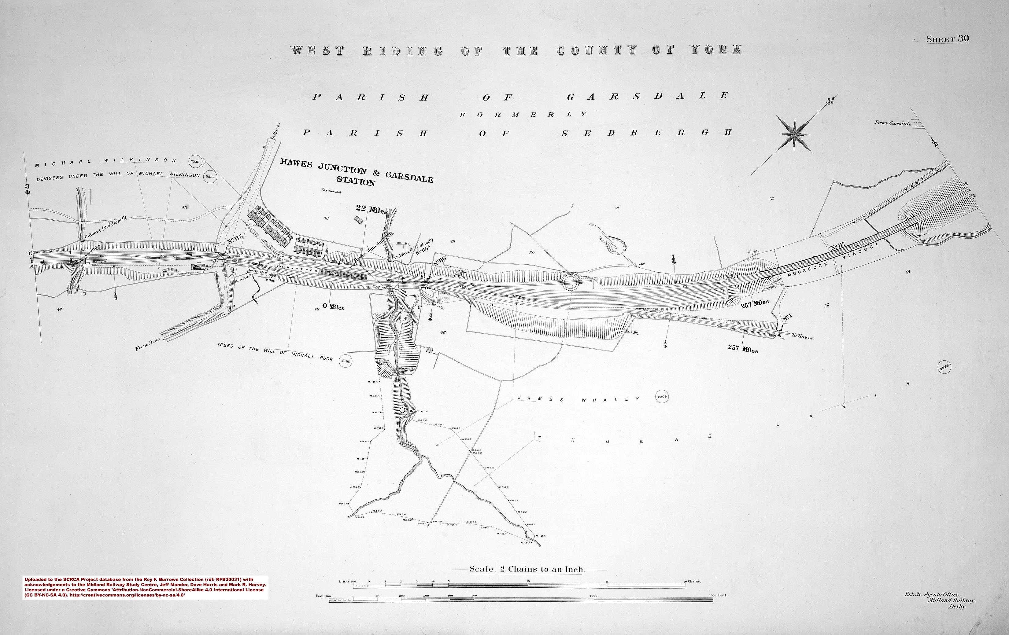
2: When planning and constructing the Settle & Carlisle Railway, the primary objective of the Midland Railway Company (MRC) was to create a fast route between West Yorkshire and Scotland. To cut a long story short, this was achieved by adapting an existing plan for a minimally engineered 'local' railway linking Hawes with Settle (and beyond). The route chosen for the MRC's more heavily engineered main line exploited the pass at Garsdale Head and a second low-level pass at Ais Gill (between the heads of Wensleydale and the Eden Valley). From Garsdale Head, the MRC constructed a branch line to serve Hawes (thereby satisfying the supporters of the original scheme). Hawes Junction station (now known as Garsdale) was built to serve the local population and to facilitate the transfer of passengers & goods between the main line and the branch. Constructing a booking office to one of the standard designs at this location would have been prohibitively expensive (due to the steeply sloping nature of the site and the need to purchase additional land). A non-standard booking office was therefore provided on the island platform, but its design was constrained by the narrow width of the platform and the need to provide a canopy to protect interchange passengers from the weather. The facilities provided in this building included a porters' room, an office for the Station Master, a booking hall, a ladies' waiting room and toilet facilities for both ladies & gentlemen. A separate waiting shelter was also constructed on the island platform.
3: The MRC had a preference for small engines and, as a consequence, 'pilot engines' were needed to assist the heavier trains up the long climbs to the high-level section between Ais Gill and Blea Moor Tunnel. The MRC provided facilities at Hawes Junction to allow these engines to be detached, refilled with water, turned, and returned 'light engine' to perform their next tour of duty.
These operations required a large resident workforce. However, there was a limited supply of local accommodation, so the MRC had to build sixteen 'cottages' (terraced houses) beside the station (Location IDs 256560, 256590 & 256620) and a further six beside Bridge SAC/118 at Moorcock (Location ID 257270).
During the planning phase, and for the first 25 years of operation, the interchange station was known as 'Hawes Junction'. In January 1900, the name of the interchange station was officially altered to 'Hawes Junction and Garsdale' (to better reflect its position at the head of the Garsdale valley). In September 1932 the official name was shortened to 'Garsdale', thereby losing the reference to the railway junction (Hawes Junction).
At some point circa 1957, the booking facilities were moved to the adjacent waiting shelter and the original main station building was demolished.
The Hawes Branch closed to all traffic on the 16th of March 1959 and Garsdale officially ceased to be the location of a junction on the 8th of December 1963. Fortunately, Garsdale is still served by a regular passenger service on the Leeds - Settle -Carlisle line (part of the UK's national rail network).


, from SW.")

.")
.")
.")
.")