SCRCA structure 247780: Bridge SAC/66 - Ribblehead Viaduct aka Batty Moss Viaduct (PROW - bridleway / track)

SCRCA Location Introduction

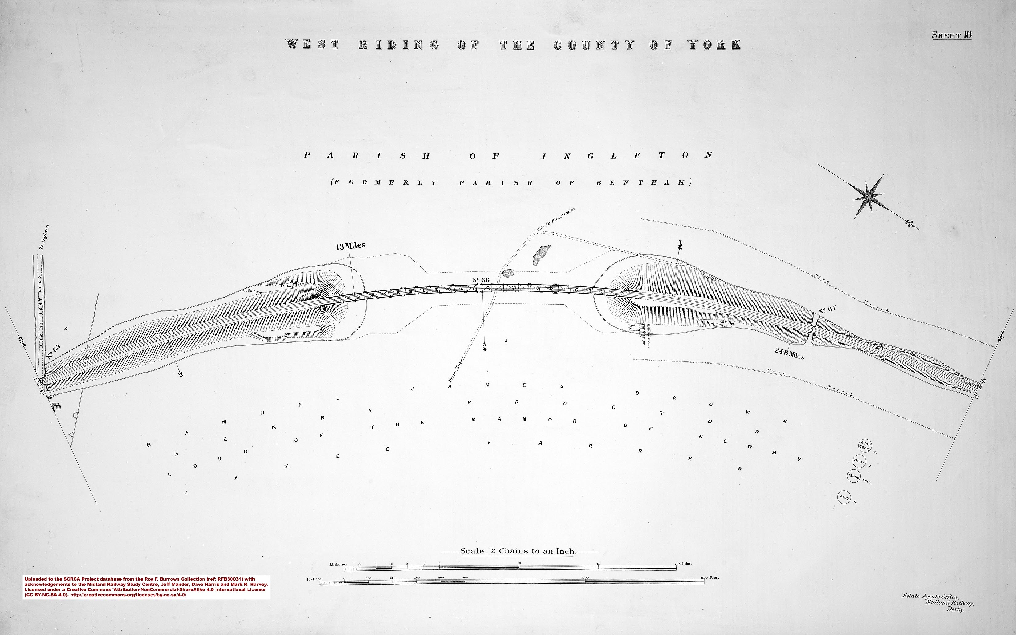
Ribblehead Viaduct (also known as Batty Moss Viaduct and Bridge SAC/66) is the longest viaduct on the line. It is 440 yards long, 100 feet high, has 24 arches and it carries the Settle-Carlisle Railway over a dry valley known as Batty Moss.

The viaduct was built as a free-standing structure. The abutments at each end are a similar height to the piers, although they appear to be shorter because the embankments were built-up around them.

Before the navvies could build the piers and abutments, they had to dig holes up to 25 feet deep through peat and boulder clay to reach the limestone bedrock. Piers 6, 12 and 18 are known as 'king piers'. They are twice as wide as the others and they help to make the viaduct very strong. They were hollow when built, but have since been filled with rubble, sand and a special cement grout.

Ribblehead Viaduct: Elevation view from the north-west

Key details from the Location Record

Location Type
Bridge (Viaduct)
Location Variant
Span - Arch (multiple)
Assessment status
Assessed
Current Use(s)
Railway ops
Shown on a land plan?
Yes 
Construction / installation period
2: MR construction phase (1869 to 31st Dec 1876)
Distance from London St.Pancras
247 miles and 60 chains
Position relative to running lines
Below
Visibility
This location IS visible from nearby publicly accessible land.
Accessibility (ease of access)
Easy
Protection Category
Listed, Grade II Star
Geographic Location
  View this location on mapping. or on aerial imagery.

List Entry Extract(s)

The information quoted below has been extracted from the relevant List Entries in 'The National Heritage List for England (NHLE) (https://historicengland.org.uk/listing/the-list/).

Tip: To open the full extract, click / tap on the List Entry Number in the left hand column.

List Entry Number (LEN) List Entry District List Entry Name
1132228 Craven BATTY MOSS RAILWAY VIADUCT

Image Gallery

Tips: To view a larger version of an image, click on its thumbnail (i.e. the small image). To view the acknowledgements and notes associated with an image, click / tap on the image title.

Context views

Elevation views

Detail views

Cab-views


Errors and omissions
Reasonable efforts are being made to ensure the accuracy of the information obtained and uploaded as part of the SCRCA Project. However, it is possible that a few errors will have crept-in. If you notice any such errors, we would be grateful if you would bring them to our attention using the SCRCA Project Contact Form. The Friends of the Settle-Carlisle Line and the members of the SCRCA Project Team do NOT guarantee the accuracy of the information contained in this database. If you intend to use and / or act upon any of this information, you are advised to verify its accuracy BEFORE doing so.